|
According to Wu et al (2016), it is more difficult to determine the motion of the Philippine plate than it is for other plates. This is due to the Philippine plate being surrounded by subduction zones; this separates the plate from spreading ridge and hot-spot reconstruction systems, both of which are useful resources when attempting to constrain plate motion with a high degree of accuracy. However, there are additional methods that can be used to analyze plate motion. One such method is paleomagnetism.
Paleomagnetic data As you can see from Figure 1 (Wu et al, 2016), the Philippine plate has moved northward approximately 20 degrees in latitude over the past 40 Ma. Figure 2 is from Hall et al. (1995) and is based solely on data from the ODP-DSDP sites; these data also show a latitude change of 20 degrees since 40 Ma. Paleomagnetic results also provide information about the rotation of the plate. In Figure 2b, you can see the rotation values from all the paleomagnetic studies as well. As you can see, studies recorded approximately 90 degrees of plate rotation over 40 Ma. Figure 2 (right): Diagram representing latitude change over time from only the ODP-DSDP sites. From Hall et al (1995).

Figure 3 (above): Comparison of latitude values from reconstruction models and paleomagnetic data at various locations. From Wu et al (2016).
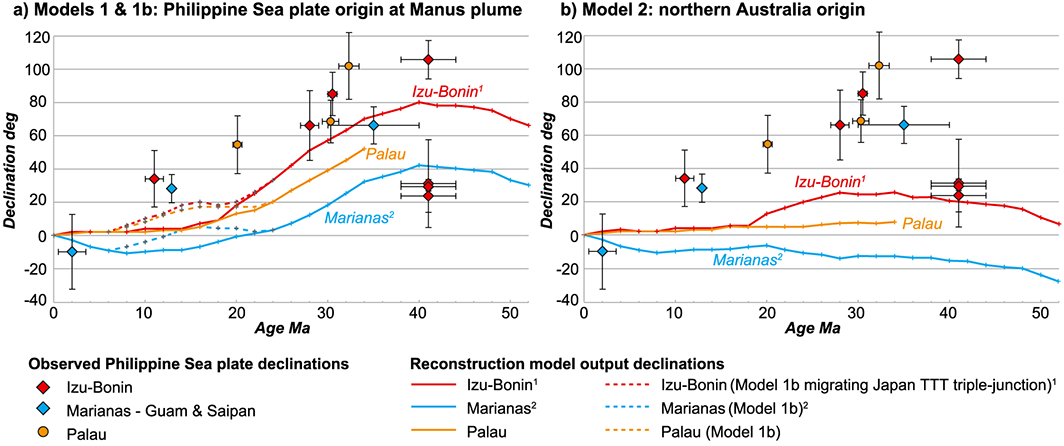
Figure 4 (above): Comparison of reconstruction models and paleomagnetic data for plate rotation. (a) provides reconstruction values from Model 1; (b) provides reconstruction values from Model 2. From Wu et al (2016).
GPS
Zang et al (2002) report a NW direction of the Philippine plate based on GPS data. This direction of motion is consistent with findings from reconstruction modelling (Wu et al, 2016). Figure 5 gives a succinct summary of the motion of the Philippine plate. As you can see, the highest rates of plate motion occur on the west side, with velocity increasing southward along the western boundary. On the eastern boundary, the opposite pattern occurs; the highest velocities are to the north and the lowest velocities are to the south. Finally, it is interesting to note that the direction of motion changes between the east and west side of the plate boundaries. On the west side of the plate, the plate is moving at an approximately 45 degree angle, while on the east side, it is moving at an approximately 25 degree angle. Finally, if you assume the average velocity of the plate (based on these GPS measurements) is approximately 50 mm/yr, you can see if this fits in with the predictions made with the paleomagnetic data and the reconstruction modelling. 50 mm/yr * 40 Ma = 2000 km. According to the Google Maps distance measuring tool (see Figure 6), this is a reasonable distance for NW movement over 20 degrees of latitude. |

Figure 1 (above): Diagram synthesizing data from every paleomagnetic study of the Philippine Plate until 2016. (a) provides data on latitude change; (b) provides data on plate rotation over time. From Wu et al (2016).

Reconstruction modelling
Another method of determining Philippine plate motion is reconstruction of past plate behavior. Wu et al (2016) performed a reconstruction that attempted to reconcile the behaviors of 28 plates and determine the motion of the Philippine plate. The diagram to the left is the result of this reconstruction. This study actually modeled two reconstructions: one in which the origin of the Philippine plate was the Manus plume (Model 1) and one in which the origin of the plate was northern Australia (Model 2). To the right are graphs comparing both models to the paleomagnetic values for different regions of the Philippine plate. The authors note that their preferred model is Model 1, because it fits the paleomagnetic data points better than Model 2 does. Overall, these reconstructions provide nearly the same results as the paleomagnetic data. For instance, while you can see that (e) and (f) have a change in latitude of approximately 10 degrees, and (b) has a latitude change of almost 30 degrees, the rest of the graphs show a latitude change of 20 degrees. This value of 20 degrees fits exactly with the paleomagnetic data. The rotation values are also similar to the values from the paleomagnetic data, as seen in the diagram to the right. Again, the values from Model 1 (4a) more closely match the paleomagnetic values than the values from Model 2 (4b) do, though none of the reconstruction models match the values from paleomagnetic data. The model at Izu Bonin comes closest to matching paleomagnetic values (for both Model 1 and 2) but does not quite reach the paleomagnetic values in either case. 
Figure 5 (above): Diagram of Philippine plate velocity based on GPS measurements. Velocities provided are relative to the plate on the other side of the boundary (for example, PH rate on the PH-CR boundary is given relative to CR). From Zang et al (2002).
|

Figure 6 (above): Distance estimate of an approximate travel path of the Philippine plate, northwest over 20 degrees of latitude. From Google Maps (accessed April 6, 2017).
Conclusions
Each of these approaches to determining plate motion has its own strengths and weaknesses.
Paleomagnetism and reconstruction modelling are similar in that they use evidence of long-term geologic trends (such as seafloor spreading or subduction) to determine the history of the area and the plate motion. It is therefore not surprising that the results from these two methods are similar. In fact, it seems that the best results come from synthesizing these two approaches. Paleomagnetism is useful for definitively constraining where the plate was at a given point, but it can't do much more than that. Reconstruction is important because it provides a mechanism and an explanation for plate behavior, but without hard data to confirm the model, it is essentially an educated guess.
On the other hand, GPS data is quite a different method from the first two methods. For one thing, GPS data is only as old as the GPS stations themselves, which means this method can not be used for reconstruction modelling. This also makes it difficult to extrapolate any extended length of time into the future, something which is possible through reconstruction modelling. However, the high degree of accuracy in GPS measurements as well as the ability to place as many stations as you would like makes GPS highly ideal for constraining current motion with a high degree of accuracy. Using GPS allows you to observe a higher degree of complexity than is possible through the long-term methods (paleomagnetism and reconstruction modelling).
Overall, all three methods (paleomagnetism, reconstruction modelling, and GPS) for constraining plate motion have their own unique benefits and drawbacks.
References Cited
Google Maps. (n.d.). Retrieved April 06, 2017, from http://maps.google.com/
Hall, R., M. Fuller, J. R. Ali, & Anderson, C. D. (1995c). The Philippine Sea Plate: Magnetism and reconstructions. Active Margins and Marginal Basins of the Western Pacific, pp. 371–404, AGU, Washington, D. C., doi:10.1029/GM088p0371.
Haston, R. B., & Fuller, M. (April 10, 1991). Paleomagnetic data from the Philippine Sea Plate and their tectonic significance. Journal of Geophysical Research: Solid Earth, 96, 6073-6098.
Watanabe, S., Ishikawa, T., & Yokota, Y. (December 01, 2015). Non-volcanic crustal movements of the northernmost Philippine Sea plate detected by the GPS-acoustic seafloor positioning. Earth, Planets and Space, 67, 1, 1-9.
Wu, J., Suppe, J., Lu, R., & Kanda, R. (2016). Philippine Sea and East Asian plate tectonics since 52 Ma constrained by new subducted slab reconstruction methods. Journal of Geophysical Research: Solid Earth, 121, 6, 4670-4741.
Zang, S. X., Chen, Q. Y., Ning, J. Y., Shen, Z. K., & Liu, Y. G. (September 01, 2002). Motion of the Philippine Sea plate consistent with the NUVEL-1A model. Geophysical Journal International, 150, 3, 809-819.
